Forage Fish Mapping
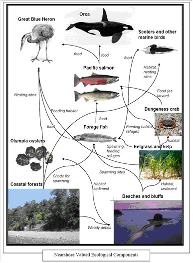
Forage fish are small fish that are eaten by larger fish, marine birds and some mammals. Forage fish in our region include Pacific herring, surf smelt, sand lance, juvenile salmon, and other small fish. Because these species are key to many food webs, it is vital that we learn what we can about them and protect their habitat in order to support our commercial fisheries, tourism industry, and quality of life. Also, by mapping where forage fish populations spawn, we can gather some indication of the health of the nearshore ecosystem.
Information regarding spawning habits and locations of sand lance and surf smelt, in particular, is limited. Many forage fish species, like other fish, have specific types of habitat that they inhabit and spawn in. This means that they are very susceptible to changes in their habitat, often created by people.
Sand lance and surf smelt are especially vulnerable to human impact because they spawn and spend time in the upper intertidal area of sandy beaches. In urban areas, this zone is often heavily armoured by land owners and local governments attempting to control natural beach processes that can cause erosion.
The armouring of a shoreline can alter the current from a movement along the shore, to a strong digging action face-on to the beach. This change in current can result in the direct loss of spawning sites for sand lance and smelt. Once gone, the restoration of that habitat would be either impossible or too costly to imagine.
The Seagrass Conservation Working Group has begun to train its member communities to map the potential habitat for key species such as sand lance and surf smelt. By knowing where the habitat is, and identifying specific spawning beaches, communities can better plan for a healthy nearshore
Recent beach seines show use in our nearshore by pipefish, juvenile salmon, gravid (pregnant) Surf smelt, and other species. A pilot project samples were taken at selected areas near the Englishman River estuary. MVIHES plans to expand this work to match the other nearshore inventory work they have done.
Shoreline Modifications
To understand how hardening the shoreline can change our beaches, it is important to know how a beach works.
Beaches do not sit idle. They are always changing through the seasons and over time. They are dynamic. They change in size, and type of substrate, affected by storms, tides and currents. Accreted lands (lands that grow as sediment is naturally deposited there) grow and shrink over time.
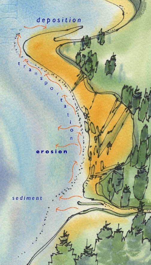
As the image below shows, beaches are typically formed by currents picking up sediments (e.g. fine sand) from mouths of rivers, and from the base of eroding cliffs and bluffs. The currents then carry the sediment along the shoreline until they reach a place where they deposit the sediment. It is that deposit zone that sandy beaches grow and are maintained. Without a regular source of fines, or sandy sediment, these beaches can’t be nourished and will change from sandy to gravel and/or cobble depending on the currents and waves and sediment sources.

MVIHES has mapped the shoreline modifications, including shoreline hardening and anthropogenic modifications, on the nearshore between Craig Creek and Little Qualicum River.