Welcome to the second in a series of "Volunteers on the Go". Our volunteers are proving very resilient by continuing to do MVIHES work while following the recommendations of BC's health officers in fighting COVID-19 (i.e. still no hugging and kissing allowed). Here are some more things we are doing.
Stream Flow Monitoring
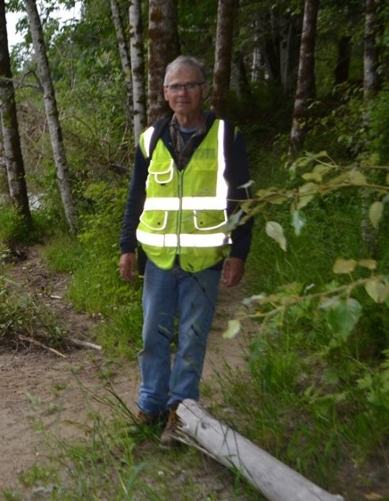
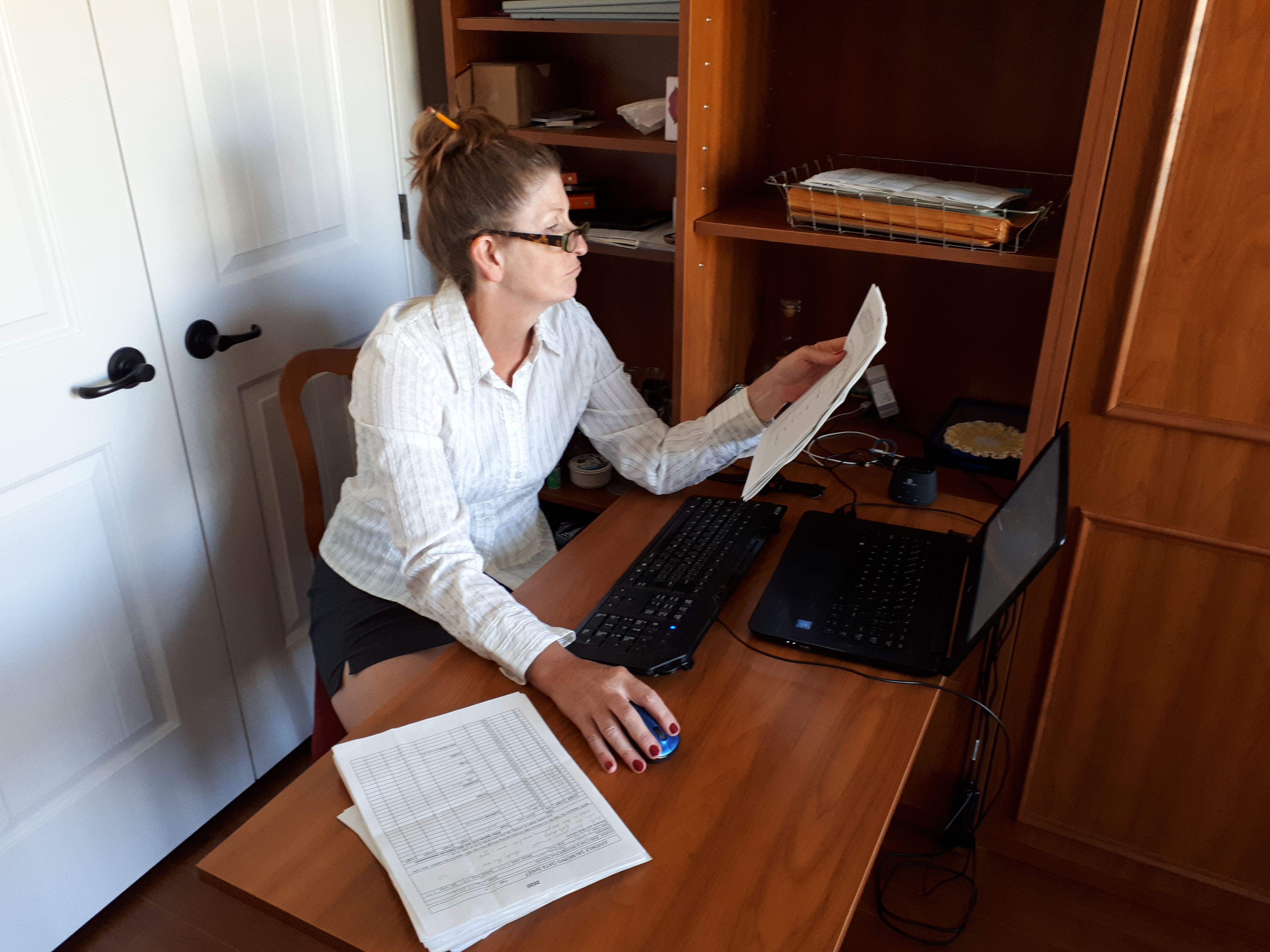
A big thanks to Shelley Goertzen (right hand photo) who is our Secretary, keeping us all organized and taking the minutes of our Board Meetings, sending out the MailChimp messages, and the most exciting job of all (as seen by the expression on her face), entering all the data from the smolt trap and other fish surveys into a spreadsheet for Department of Fisheries and Oceans (I think she's asleep). The rest of the time she is out doing field work like Stream Flow Monitoring.
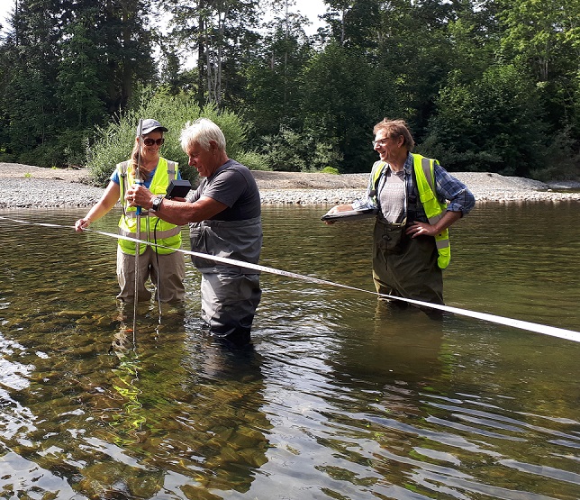
MVIHES is conducting streamflow monitoring in the Englishman River this summer using a device called a Flowtracker, to help determine if there are sufficient flows for sustaining fish populations. As seen in the photo to the left, Shelley is operating the the Flowtracker controller and Dick Dobler (you may remember him in a previous article as "Catcher of the Fry") is using the "wading rod" which has the Flowtracker probe attached to the bottom. Chris Smith (you may know him as the Glaskrafter) is holding the clipboard, waiting for data. And taking the photo is Pete Law.
Flow monitoring sites include upstream and downstream of the new water intake for the Parksville water treatment plant, the old water intake, and downstream of the old water intake before the Englishman River Estuary. If you are interested in particpating in this or other projects, see below.
UPCOMING PROJECTS
1. YELLOW FISH LAWN SIGNS. A few years ago we had a Salmon Friendly Lawn program that promoted water conservation in the Oceanside area. Residents made a pledge to not water their lawns in the summer months and received a yellow fish lawn sign to signify their pledge and get their neighbours interested. We are reviving the program and are looking for some people who have skills and equipment for woodworking to produce the wooden fish. We will supply the wood and a fish template.
2. GROUNDWATER WELL MONITORING. Several private wells in the Englishman River watershed contain data loggers that collect information on water levels every four hours all year round. This information is used to help the RDN understand the state of the aquifers in our region. MVIHES downloads the data off the loggers and sends it to the RDN and GWS which is a hydrological engineering company that has created a computer model of our aquifers. We are planning our next round of downloads for September and are looking for people to help
If you are interested in particpating in any of these projects, please contact us at This email address is being protected from spambots. You need JavaScript enabled to view it.
The C.W. Young Side Channel is a channel constructed off the Englishman River within the Englishman River Regional Park (ERRP). The side channel is a Fisheries and Oceans Canada (DFO) salmon enhancement operation, intended to provide over-wintering habitat for Coho Salmon fry reared in the Englishman River. Beaver dams within the channel have created the 2.8 ha marsh wetland called the Beaver Pond. A map showing an overview of the Beaver Pond in the ERRP is below.
In 2018, two small colonies of yellow iris (shown in the photo to the left), an invasive species that fills in wetlands and displaces aquatic habitats, were discovered in the Beaver Pond. This was a real concern for us, as well as for the Regional District of Nanaimo Parks Department (RDN), because Coho fry inhabit the Beaver Pond. Their habitat was at risk of filling in with yellow iris, leaving no open water for the fish. Plus, the yellow iris would probably spread into other areas of the side channel where Coho fry inhabit.
The RDN contracted the Coastal Invasive Species Committee to remove the yellow iris in summer of 2019 with financial assistance from DFO. MVIHES was asked to monitor the Beaver Pond for five years, starting in 2019, to document the success of the eradication of the yellow iris and identify other infestations of invasive species.
For those of you who have taken the Wetlandkeepers course, you know that the typical method for assessing wetlands is to establish a number of transects that cross the wetland in several locations and collect information on vegetation while walking along the transects. Since we would be monitoring the wetland every year for five years, we chose a method that was first developed by the forest industry: Permanent Sample Plots, or PSP's. A PSP allows you to go to the same location year after year and monitor for changes without having to assess the entire area which would be very labour intensive. The information collected was based on the guidelines in the Wetlandkeepers Handbook. MVIHES selected seven locations for PSPs, two which included the yellow iris infestations. A map showing their locations is below.
So what did we find? Well, we didn't find any yellow iris because the Coastal Invasive Species Committee had done an awesome job of removing it a few weeks before we surveyed those plots. Unfortunately, we found that six of the seven plots contained another invasive species: reed canary grass. And reed canary grass was the dominant species in five of those six plots! You can read the technical report for last year's monitoring here.
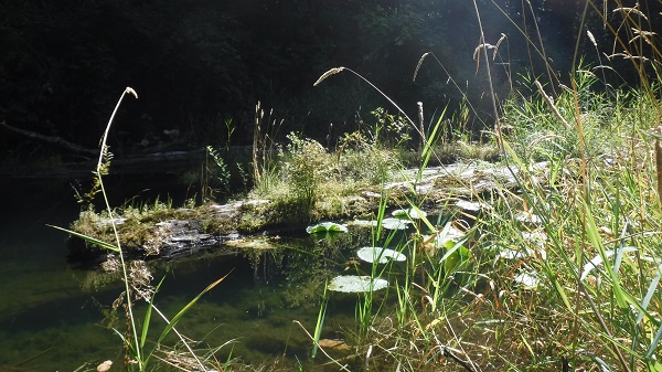
Reed canary grass is a perennial sod-forming grass species that prefers wetlands. Sod-forming means it creates it's own soil and changes a marsh into a dry meadow. You can see tall stalks of the grass growing amongst cattails in the photo on the left. Although reed canary grass is native in North America, varieties of this grass have been introduced from Europe and Asia. These varieties are aggressive in the central and western regions of North America, invading and filling in wetlands. The most probable source of the aggressive variety in the wetland are seeds from pasture grasses and hay bales for cattle and horses on local farms. Seeds may have been carried into the wetland by wind or birds, or arrived in the hair of horses and dogs on the park trails.
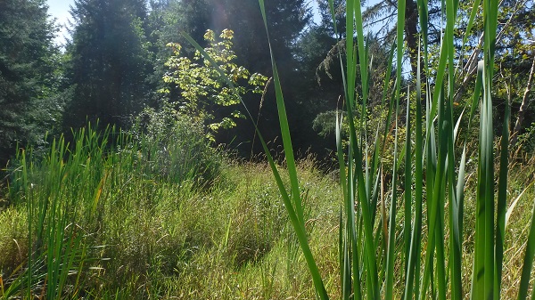
The only plot that did not contain reed canary grass is shown on the right. Many Coho fry were observed in this plot which was all open water, meaning there was no vegetation growing out of the water like cattails or grass. Reed canary grass can be seen in the background. This plot was the deepest with a 1.2 m water depth which is probably too deep for the grass to establish. All other plots had depths between 0.0 m and 0.5 m.
Open water occupied 10 percent to 40 percent of the area in other plots, but the only one where coho fry were observed is shown in the photo on the left. The rest of the areas within the plots contained mostly reed canary grass with some cattails, rushes, sedges, and shrubs like salmonberry, elderberry, hard hack, willows, black twinberry and Pacific nine-bark.
The reed canary grass is an even bigger threat to fish habitat in the wetland than the yellow iris because of the extent to which it has invaded. There is no easy way to remove or control it. The photo to the right shows how the grass has filled in the open water that existed between cattails in most of the plots. When the grass has filled in the spaces, shrubs and trees are able to encroach, turning the marsh into a wet meadow and eventually a woodland.
We are in communication with the RDN to find an approach for managing the reed canary grass. In the meantime, we have almost completed this year's survey of the PSP's and will be interpreting the results in a report.
Welcome to the first in a series of "Volunteers on the Go". Our volunteers are proving very resilient by continuing to do MVIHES work while following the recommendations of BC's health officers in fighting COVID-19 (i.e. no hugging and kissing allowed). Here are a couple of the things we are doing.
Photo Point Monitoring
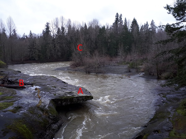
Michael Castonguay has been conducting photopoint monitoring on the Englishman River for over a year now. This involves taking photos along the river in precisely the same locations every few months so that changes in the river banks, gravel bars, log jams, etc. can be tracked. It's important for understanding the power of the river and the dynamics of the river channel.
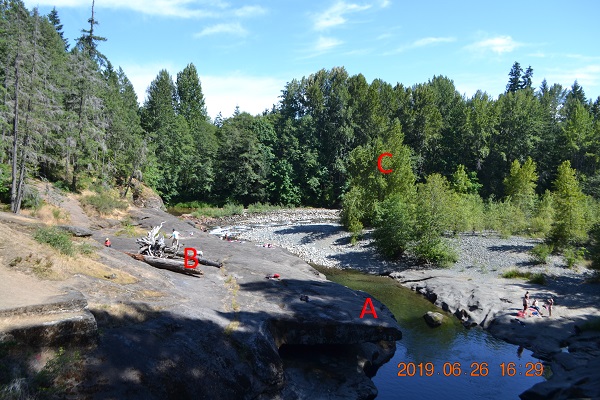
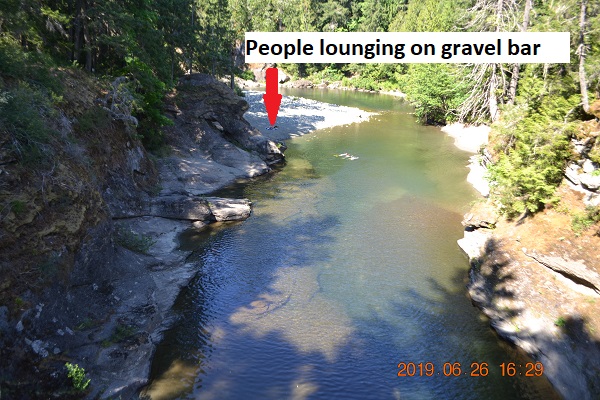
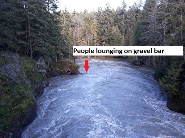
Below are some examples of how the river changes with the seasons. The first two photos were taken looking upstream from Top Bridge and the next two photos were taken looking downstream of Top Bridge. The left-hand photos were taken in June 2019 and right-hand photos in February 2020. Some landmarks have been added to the photos so comparisons can be made of the water levels.
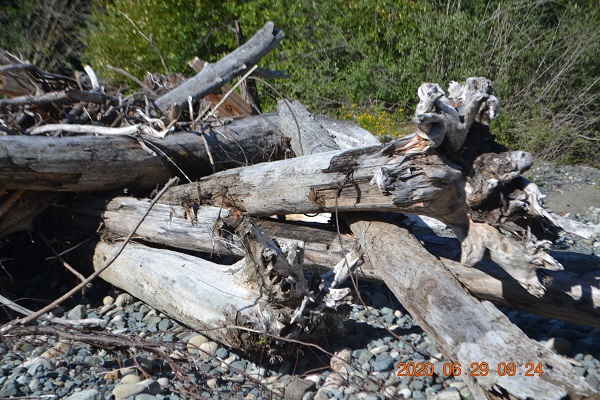
I'm sure the people lounging on the gravel bar were gone before the winter rains arrived...pretty sure. The pictures below were taken in June 2020, and show what the high winter flows are capable of. The photo on the left shows the remains of a woody debris structure that was constructed using large logs and stumps anchored with cables to boulders on the shore. If you look closely, you can see one of the cables. The purpose of the structure was to create pools and shade for fish. Chewed up and spat out by the river it was meant to help. The photo on the right shows a chunk of the stream bank that was eroded off and moved into the stream channel, trees and all. The lesson here is: don't mess with Mother Nature. Thank you, Michael, for capturing these great images.
Wetland Monitoring Program
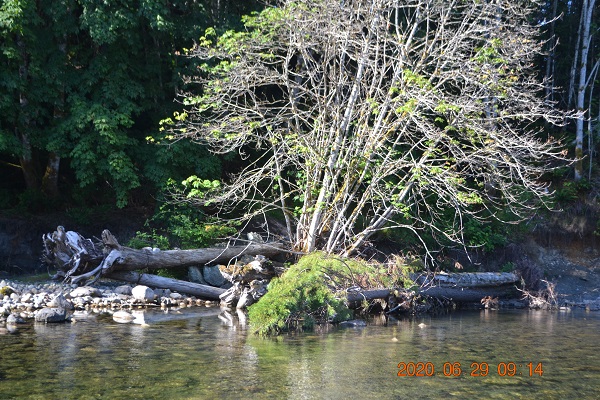
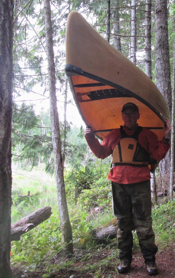
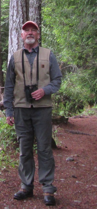
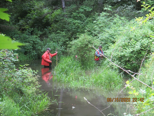
The next photos were taken in June 2020, and show a wetland survey in progress in the CW Young Side Channel in the Englishman River Regional Park. The Side Channel provides rearing habitat for Coho Salmon fry. The wetland was created by beaver dams in the Side Channel. Pete Law and Barb Riordan are in the photo on the left. Notice the nice social distancing. Pete and his canoe are in the far right photo, and Jim Goodwin is in the middle. Jim is with the Arrowsmith Naturalists and is conducting bird surveys as part of the wetland survey. Two small colonies of yellow iris, an invasive species, were discovered in the wetland in 2018. The Regional District of Nanaimo Parks Department (RDN) arranged for the yellow iris to be removed by the Coastal Invasive Species Council, and asked MVIHES to monitor the wetland for other colonies of invasive species for five years, starting in 2019. An article summarizing last year's monitoring is available here. This year's survey is not yet complete so there are still opportunities to participate.
Upcoming Projects
1. Stream flow monitoring in the Englishman River using a FlowTracker. We will measure the flow in the ER by taking a series of velocity measurements through the cross section of the river at different locations. These measurements are combined with water depths along each cross section to calculate flow rate (m3/second). This involves wading in the river so chestwaders with felts are recommended.
2. Annual water sampling of the Englishman River and its tributaries. This Includes weekly sampling for five weeks in August and again for five weeks in October. We have nine sites where we collect data on temperature, dissolved oxygen, conductivity and turbidity. Some of these sites require travelling on logging roads with scenic vistas and take you to some very pretty spots.
3. Completion of the Wetland Survey mentioned above. This involves some hiking through the bush and wading through a marsh to access our monitoring plots. We have a few spare pairs of chestwaders if you don't have your own. We will be collecting data on the number of salmon fry we see and other wildlife, measuring water depths, and collecting information on the plants growing in the plots.
If you are interested in participating in any of these projects please contact us at This email address is being protected from spambots. You need JavaScript enabled to view it.
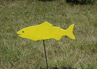 A few years ago we had a Salmon Friendly Lawn program that promoted water conservation in the Oceanside area. Residents made a pledge to not water their lawns in the summer months and received a yellow fish lawn sign to signify their pledge and get their neighbours interested. We are reviving the program and are looking for some people who have skills and equipment for woodworking to produce the wooden fish. We will supply the wood and a fish template.
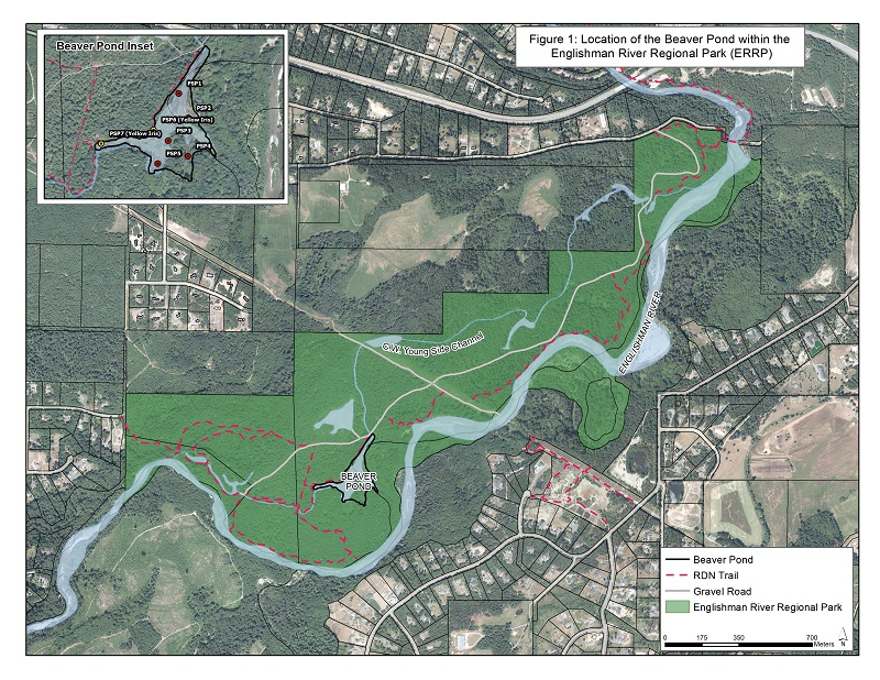
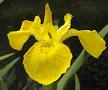 In 2018, two small colonies of yellow iris (shown in the photo to the left), an invasive species that fills in wetlands and displaces aquatic habitats, were discovered in the Beaver Pond. This was a real concern for us, as well as for the Regional District of Nanaimo Parks Department (RDN), because Coho fry inhabit the Beaver Pond. Their habitat was at risk of filling in with yellow iris, leaving no open water for the fish. Plus, the yellow iris would probably spread into other areas of the side channel where Coho fry inhabit.
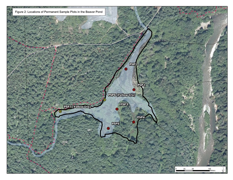
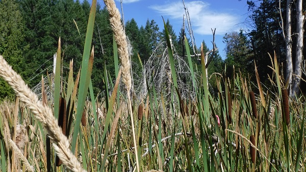 Reed canary grass is a perennial sod-forming grass species that prefers wetlands. Sod-forming means it creates it's own soil and changes a marsh into a dry meadow. You can see tall stalks of the grass growing amongst cattails in the photo on the left. Although reed canary grass is native in North America, varieties of this grass have been introduced from Europe and Asia. These varieties are aggressive in the central and western regions of North America, invading and filling in wetlands. The most probable source of the aggressive variety in the wetland are seeds from pasture grasses and hay bales for cattle and horses on local farms. Seeds may have been carried into the wetland by wind or birds, or arrived in the hair of horses and dogs on the park trails.
 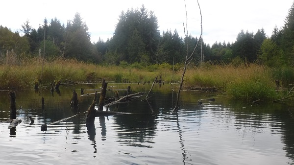 The only plot that did not contain reed canary grass is shown on the right. Many Coho fry were observed in this plot which was all open water, meaning there was no vegetation growing out of the water like cattails or grass. Reed canary grass can be seen in the background. This plot was the deepest with a 1.2 m water depth which is probably too deep for the grass to establish. All other plots had depths between 0.0 m and 0.5 m.