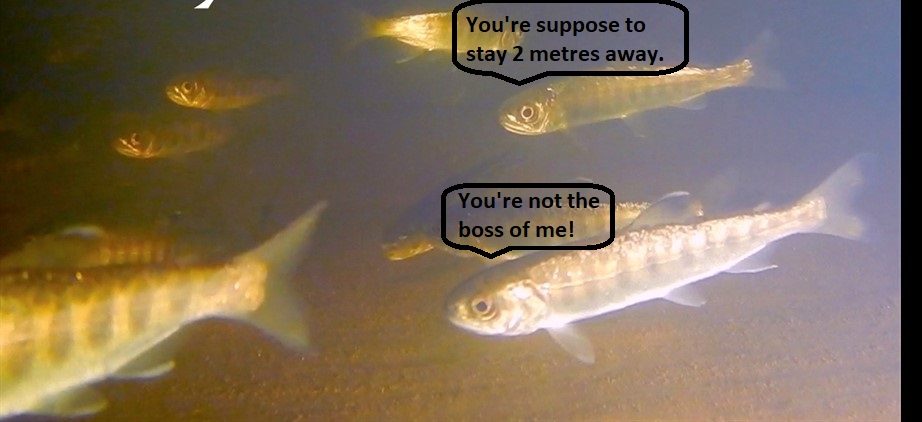
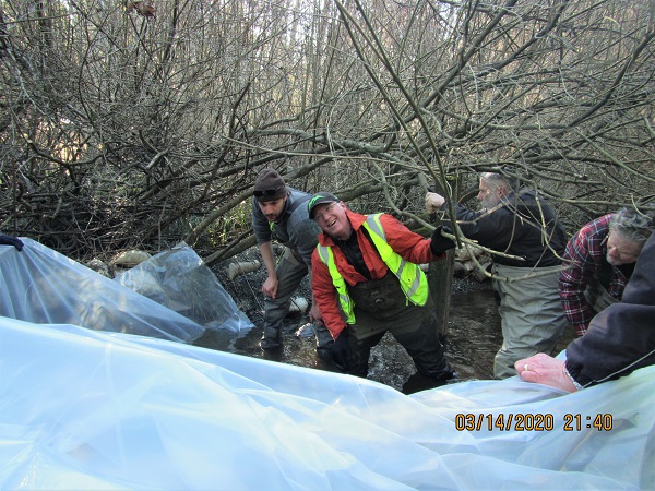
Two of our diligent volunteers, Shelley and Carl, are conducting the annual Coho smolt count on Shelly Creek admidst the COVID 19 pandemic by staying 2 m away from each other. The fish, on the other hand, are not behaving themselves at all.
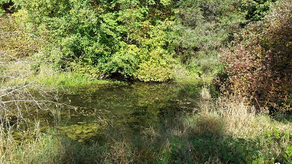
Every winter, flooding of the Englishman River sweeps Coho Salmon fry into the Martindale Pond (shown in the photo to the left), a section of the creek upstream of Martindale Road in Parksville. The fry remain in the pond for the winter, sheltered from the turbulent flows of the Englishman River, where they develop into smolts in the spring. The migration back to the Englishman River begins when water temperatures increase and oxygen levels in the pond begin to drop.
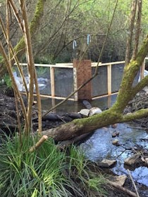
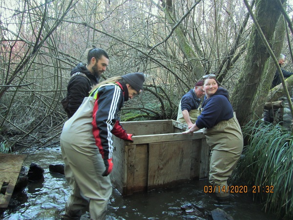
Each spring, we set up the smolt trap in Shelly Creek to count the Coho Salmon smolts as they migrate out of the pond to the Englishman River and out to the ocean. The trap includes a fence that directs the fish through a pipe into a box where the fish are held until they are counted and released into the creek, as seen in the photos to the right. (All photos were taken before social distancing measures.)
The smolt fence and box were installed by volunteers on March 15.
Normally, four to five people come to the the trap each morning to count the fish. But shortly after installation, the Province of BC advised people to self-isolate and conduct social distancing when around others to prevent the spread of the Coronavirus. MVIHES has limited the counting to two people, with one person recording data and a second handling the fish so that a distance of 2 m between volunteers can be maintained and equipment is not handled by more than one person. Not as much fun as previous years but if we all behave ourselves, this too shall pass.
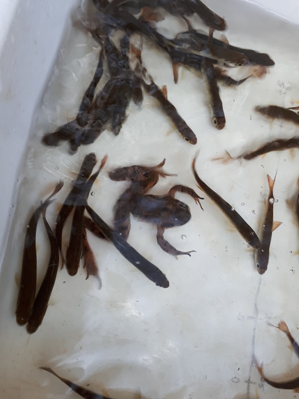
The fish have a completely different attitude. There were 172 of them packed into the box today! In fact, a total of 1,115 smolts have been counted so far and we still have a few weeks of counting to go. The average number of smolts counted in a season is around 4,000, with the 2013 and 2018 seasons having over 7,000 smolts, and the 2012 season having over 8,000 smolts. This demonstrates the importance of Shelly Creek to the Englishman River Coho Salmon stocks. To learn more about Shelly Creek and read the latest report for comparing results from previous years, click here.
Smolts (and a red-legged frog) are netted from the box and placed in a tub to be identified and counted.
Just sit right back and you'll hear a tale, a tale of a fateful trip, that started on this marshy pond with sediment three feet thick. The boat was a floaty bathtub thingy. All that was missing was a rubber duck. One passenger set sail that day to measure up the muck............. Okay, that's enough.
Martindale Pond is a marshy area of Shelly Creek located on Martindale Road in Parksville. Every year, the pond provides overwintering habitat for thousands of Coho Salmon smolts and hundreds of Rainbow and Cutthroat Trout. The fish move into the pond from the Englishman River to escape the turbulent winter flows, and migrate back into the river in the spring when the pond warms up and the water level drops. We know this because, every spring, we set up a smolt trap to count and identify the fish as they migrate out of the pond. The fish are released after they've been counted to continue their migration.
Martindale Pond has been filling up with sediment for years from bank erosion upstream on Shelly Creek and from flooding of the Martindale neighbourhood by the Englishman River. We are concerned the pond has filled to the point where there is not enough habitat for all the fish that need it. Last summer, our Biologist, Dave Clough, developed a plan for removing the sediment and disposing of it in an environmentally safe manner. This includes the use of a dredge by a local contactor in late summer when there is usually no water flow through the marsh. Of course, all the critters that inhabit the pond in summer (turtles, frogs, salamanders) would have to be moved into a corner of the pond that will be fenced off from all the action, as required by regulations.
Last October we applied for a grant from the Pacific Salmon Foundation (PSF) to cover the cost of the contractor and traffic control personnel (since machinery will be working just off the road). In December, we learned that PSF accepted our proposal and is providing the $50,000 in funds we requested. Woohoo!!!
But this isn't a slam dunk. We still need to submit an application to the government for working in a stream. In addition to an Environmental Management Plan, the application requires a surveyed drawing of the pond perimeter and a cross-section of the sediment so we know how much sediment has to come out and from where.
Koers Engineering in Parksville agreed to survey the pond and produce the drawing WITHOUT CHARGE. Kudos to Koers for their support of community stewardship! This is where the boat comes in. After the pond perimeter was surveyed, a MVIHES volunteer who drew the shortest straw took a surveying pole with a prism on the end ($5000 to replace if the prism gets wet) out in the boat. The pole was set into the sediment in different locations in the pond so the surveyor could take his readings needed for the cross-section. No equipment was lost or damaged and we are just awaiting the drawing so we can complete our application.
We will provide updates as the project progresses.
Guy the surveyor from Koers Engineering - February 21, 2020
Last month we documented for the second year in a row that sand lance spawn on the beach at San Pareil in December.
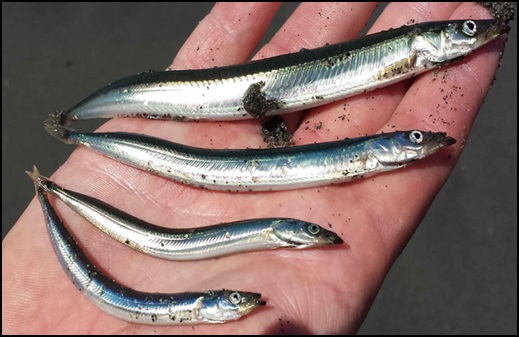
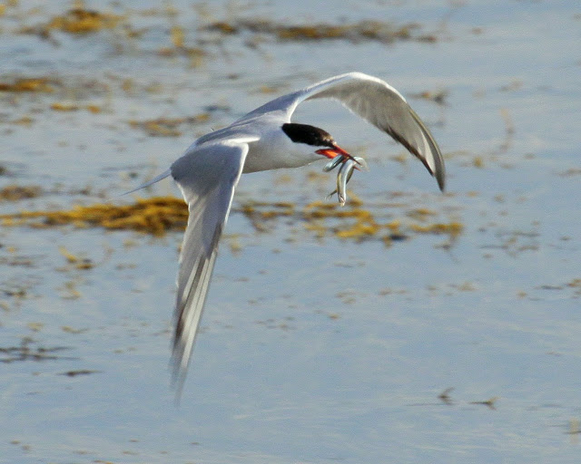
Forage fish such as sand lance are the cornerstone of marine food webs, playing an important role in the diets of salmon, humpback whales, porpoise, sea lions, seals, and marine birds. Sand lance lay tiny eggs (1mm) on pebble and sand beaches just below the high-tide line. Activities like development or construction work on shorelines can have a detrimental effect on forage fish populations by destroying eggs and embryos. For that reason, the Department of Fisheries and Oceans (DFO) has "timing windows" which are periods when it is safe to conduct work on shorelines without damaging fish and fish habitat. Unfortunately, the winter timing window for fish is December 1 to February 15. So far, we have only found evidence of sand lance spawning on San Pareil beach in December, when it is assumed safe for shoreline disturbance.
So what evidence are we referring to? Well, in June 2018, volunteers were trained in identifying and mapping forage fish spawning sites under the instruction of Ramona de Graaf, Independent Researcher and Co-ordinator of the Shore Spawner's Alliance. This included collecting sand samples below the high-tide lines and filtering and processing the sand through a series of sieves to collect the right sized sand grains to which eggs would attach. Too small to be seen with the naked eye, the processed sand is placed under a microscope and searched for eggs and embryos.
MVIHES volunteers began collecting sand samples from the beach at San Pareil on a monthly basis in 2018 and continue to do so. You may remember that on December 5, 2018 we actually found sand lance that contained ripe eggs and milt on the beach, proving the fish were using the beach as a spawning ground. In May 2019, MVIHES joined forces with the Mount Arrowsmith Biosphere Region Research Insititute (MABRRI) based out of Vancouver Island University (VIU) that was also conducting forage fish surveys. Nancy Hancock collects sand samples, Oct 15, 2019.
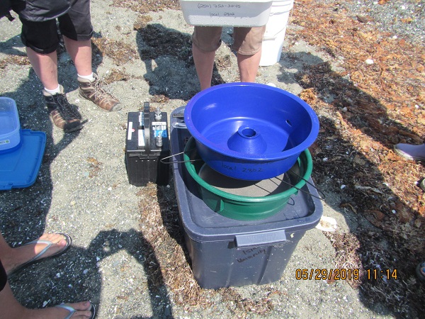
MABBRI has lent us an apparatus called a vortex, shown in the photo at right, which makes the separation of eggs from the sand easier following sieving.
On December 6, 2019 two of the sand samples we collected at San Pareil contained sand lance eggs. You can imagine how satisfying it was after all those months of sampling to finally find eggs. The longest egg hunt of our lives. Many thanks to MABRRI and VIU for the microscope work.
The importance of this work is that the beach in San Pareil can now be identified as one where protection of sand lance spawining activity is crucial. MVIHES endeavors to inform the residents of San Pareil of the importance of their beach for sand lance production. We will also urge DFO to change the winter timing window for shoreline work, at least for this area.
It will be interesting to see what our sampling in the 2020 will reveal. Stay tuned!
 Every winter, flooding of the Englishman River sweeps Coho Salmon fry into the Martindale Pond (shown in the photo to the left), a section of the creek upstream of Martindale Road in Parksville. The fry remain in the pond for the winter, sheltered from the turbulent flows of the Englishman River, where they develop into smolts in the spring. The migration back to the Englishman River begins when water temperatures increase and oxygen levels in the pond begin to drop.
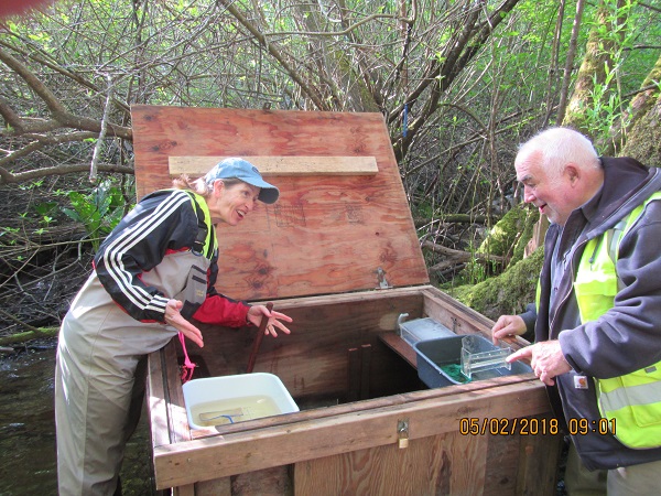
 The fish have a completely different attitude. There were 172 of them packed into the box today! In fact, a total of 1,115 smolts have been counted so far and we still have a few weeks of counting to go. The average number of smolts counted in a season is around 4,000, with the 2013 and 2018 seasons having over 7,000 smolts, and the 2012 season having over 8,000 smolts. This demonstrates the importance of Shelly Creek to the Englishman River Coho Salmon stocks. To learn more about Shelly Creek and read the latest report for comparing results from previous years, click here.
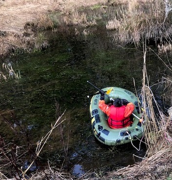 Just sit right back and you'll hear a tale, a tale of a fateful trip, that started on this marshy pond with sediment three feet thick. The boat was a floaty bathtub thingy. All that was missing was a rubber duck. One passenger set sail that day to measure up the muck............. Okay, that's enough.
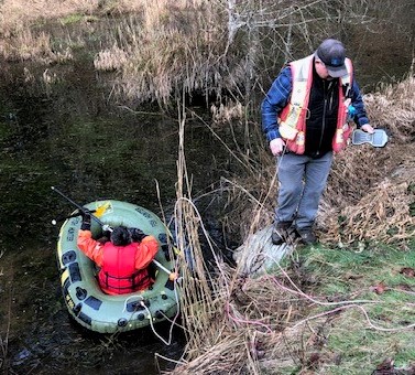

 In San Pareil in Parksville.
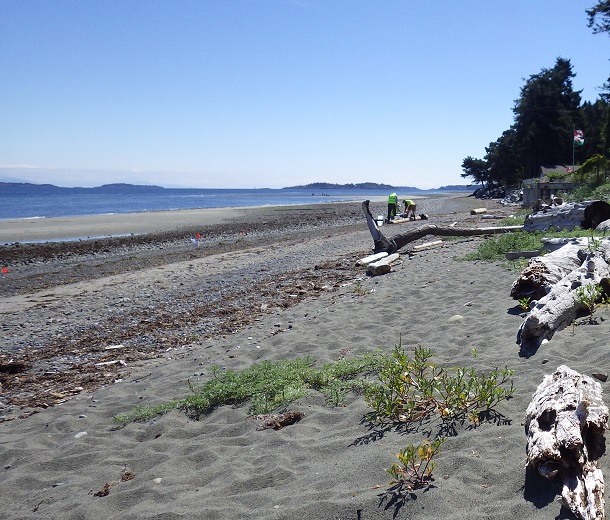
 are periods when it is safe to conduct work on shorelines without damaging fish and fish habitat. Unfortunately, the winter timing window for fish is December 1 to February 15. So far, we have only found evidence of sand lance spawning on San Pareil beach in December, when it is assumed safe for shoreline disturbance.
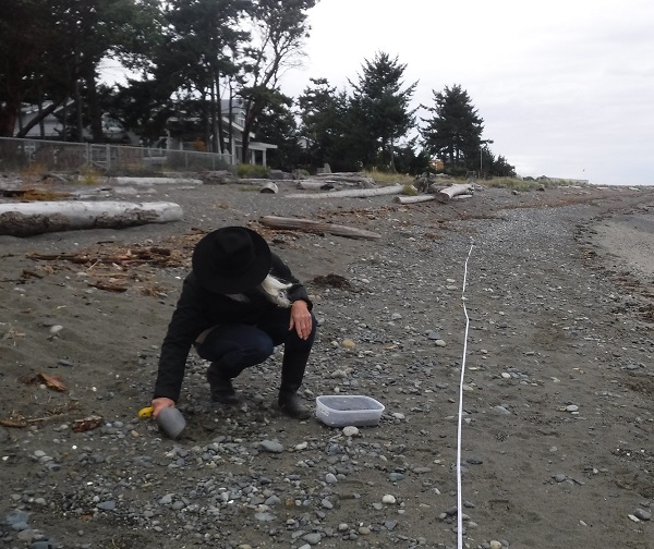
 MABBRI has lent us an apparatus called a vortex, shown in the photo at right, which makes the separation of eggs from the sand easier following sieving.