The month of May was all about beaches for our volunteers. Check out our "Sharing Shorelines" brochure about conserving shorelines, not only for sustaining marine life (and beaches), but protecting real estate as well. Many thanks to Islands Trust who produced the original brochure and allowed us to modify it for Parksville. And MVIHES vounteer Ross Peterson who did the modifying and got it published.
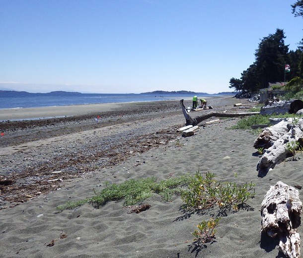
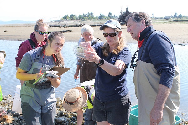
On May 29, Haley Tomlin from Vancouver Island University gave an excellent training session on surveying the spawning habitat of forage fish (Sand Lance and Surf Smelt) to the Qualicum Beach Streamkeepers. Of course, MVIHES just had to crash the party. You may remember, we were trained in forage fish surveys last year by Ramona de Graf using the State of Washington methodology. Haley, who is conducting these surveys on behalf of the Mount Arrowsmith Biosphere Region Research Institute, has created a "Citizen Science" program that simplifies the State of Washington method. The data collected from this program will be stored on the Pacific Salmon Foundation website which should make it possible to identify beaches that are important for forage fish spawning when an area is being considered for development.
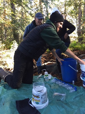
Haley is also lending us a fancy piece of equipment called a vortex (shown in photo) that is powered by a 12 volt car battery. The vortex separates fish eggs and embryos from our sand samples and replaces the manual "panning for eggs" method we have been using. Very cool. MVIHES will continue surveying local beaches for forage fish spawning habitat. If you haven't already been involved in our surveying and you would like to participate, just drop us a line at This email address is being protected from spambots. You need JavaScript enabled to view it.
On May 30, Dave Clough, our consulting Biologist for many years, lead us on another beach seining session at the Englishman River estuary. We were accompanied by Emily Vance, a reporter for PQB news. Emily wrote a great article that explains all about why we beach seine.
You may remember Braden Judson, a biology student from Vancouver Island University (VIU), who did his undergraduate research project last year on the eating habits of the resident Cutthroat Trout population in Shelly Creek. This project was the brainchild of Ross Peterson and Pete Law of MVIHES who approached VIU for a student to conduct the research. The MidIsland Castaways Fly Fishing Club provided a donation to fund Braden's travel expenses between Parksville and Nanaimo. The results of the study are in and are really interesting, if not surprising.
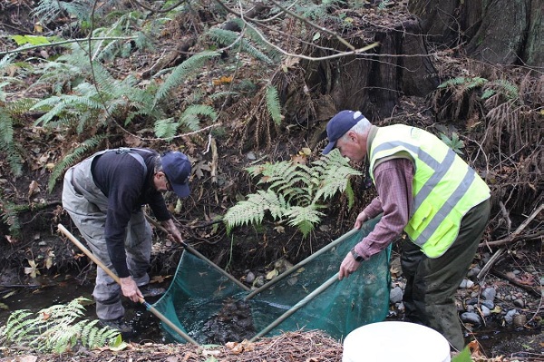
With the help of volunteers, a total of 83 Cutthroat Trout were captured with a net called a pole seine on three sampling occasions in August, September and October. Each fish was weighed, measured and its adipose fin (tiny fin made of fat at base of tail) was clipped so we can distinguish these Cutthroat Trout from those that enter Shelly Creek via the Englishman River when we operate our smolt counting fence downstream each spring.
Following these procedures, Braden perfomed a gastric lavage on each fish. I know, it sounds like a menu item for French cuisine. It's actually a scientific term for stomach pumping. It takes quite a bit of skill to extract the stomach contents of a tiny fish without harming it. The stomach contents of each fish were collected, preserved and identified in a lab at VIU. Nice work, Braden! And yes, the fish were released back into the creek, perhaps a little perturbed at having lost their lunch.
Braden found that half of the items the trout had eaten were the ususal inhabitants of creeks: mayfly nymphs, stonefly nymphs, caddisfly larvae, fly larvae and water striders.
The other half were critters that live on land: pill bugs (or wood bugs) ants, wasps, springtails, beetles and spiders. Wow, half the diet of these trout comes from land! This emphasizes the importance of vegetation along streambanks and tree canopy that hangs over creeks. These insects (and spiders) most likely fell off some foliage overhanging the water. Good to know that the ferns and shrubs volunteers planted alongside Shelly Creek in March should help keep the trout fed.
Braden's research paper is available in our digital library and can also be accessed here. We wish Braden well with his studies and thank him for his diligence. Many thanks to VIU, the MidIsland Castaways, and our MVIHES volunteers for their support. And thanks to the City of Parksville Parks Dept for letting us conduct this work in Shelly Park.
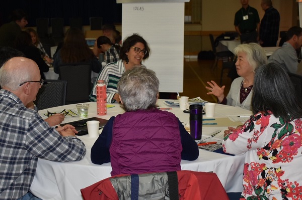
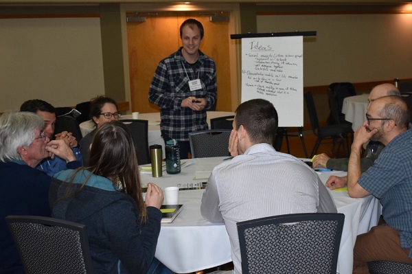
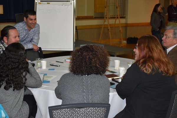
“Parksville 2019 demonstrated that a group of 200 biologists, engineers, planners, streamkeepers, politicians, administrators, and others, all with different backgrounds and responsibilities, can share a common learning experience and agree on strategies for water stewardship and stream restoration.” These were the words of John Finnie, the Regional District of Nanaimo (RDN) former General Manager for Regional and Community Utilities, at the second annual Vancouver Island Water Stewardship Symposium held in Parksville, April 2, 3 and 4.
Delegates came from far and wide – from Sooke north to Port McNeill; from Metro Vancouver east to Alberta; and from south of the border (Washington State, Virginia and Mississippi). Parksville Mayor Ed Mayne opened the Symposium with a welcome to delegates to the three-day event, co-hosted by the Partnership for Water Sustainability,Nanaimo & Area Land Trust and the Mid Vancouver Island Habitat Enhancement Society (MVIHES).
Dave Derrick - photo by David Mackenzie
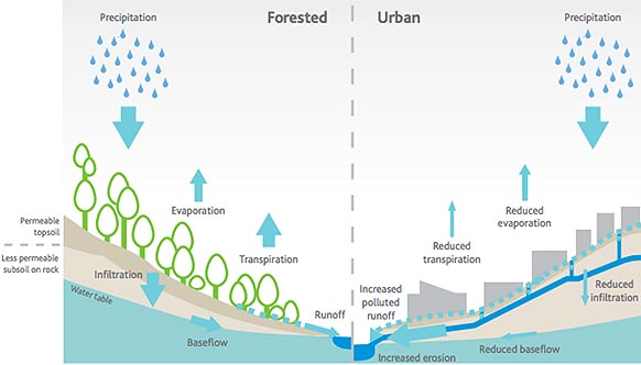
Last year’s symposium, held in Nanaimo, explained how land development using drainage systems that send rainfall straight off the land into creeks and rivers disrupts the natural flow and infiltration patterns of water on our landscape. The consequences of this disruption are more erosion and flooding, very low water levels in summer, and loss of aquatic habitat. The problem will worsen with climate change.
At this year’s symposium, delegates learned how communities can apply science-based understanding to restore the natural water balance, and about local government initiatives that are ‘getting it right’ and moving along pathways that lead to restorative land development. The restoration stories of Bowker Creek in the urban heart of the Capital Region and Brooklyn Creek in the suburban Comox Valley demonstrate how partnerships between local governments and community stewards result in success on the ground where it matters.
Dave Derrick of Mississippi (above photo), a stream restoration innovator and formerly with the US Army Corps of Engineers, conducted a workshop built around a field lecture in Shelly Creek Park. He stated, “The stability of the Shelly watercourse has been compromised by land use activities in the surrounding creekshed… why would you further damage the creek to get access [for restoration in hard to reach sections] when the real solution lies in fixing the surrounding landscape where the problems are actually created?” His distinct southern accent added intrigue to his words - oo la la!
“The Symposium has provided a huge boost to MVIHES, in our efforts to draw attention to our ‘watershed health depends on you’ program, whether it is Shelly Creek water balance restoration or future monitoring of Englishman River watershed health,” added Peter Law, MVIHES President.
Julie Pisani, Coordinator of the RDN’s Drinking Water and Watershed Protection program (DWWP), led a community engagement session for input towards an actionable vision for achieving water sustainability in the second decade of the DWWP program, with its Action Plan being updated this year.
Twenty students with the Master of Community Planning Program at Vancouver Island University (VIU) served as table facilitators for the engagement session. “The involvement of the students extended the collaboration across the generations, providing an opportunity for future leaders and planners to be involved in the discussions.”
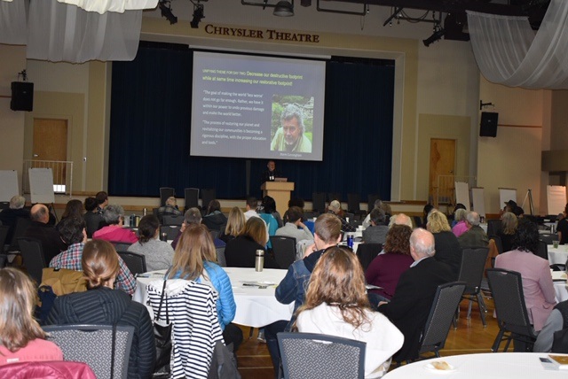
On the evening of April 3, Storm Cunningham gave an inspiring and informative talk on the strategies used by communities who have revitalized their neighbourhoods and economies by restoring abandoned and deteriorating infrastruture (such as railway bridges and buildings) and remorphed them into facitilies needed for communties to thrive. Storm is from Washington D.C. and the author of "The Restoration Economy", "reWealth", and the soon to be released "RECONOMICS: The Path to Resilient Prosperity". On the last day of the symposium he gave a presentation on how applying the same strategies to land development can lead to restoration of the natural hydrology of creeks and aquifers: by decreasing our destructive footprint while increasing our restorative footprint. “The goal of making the world ‘less worse’ does not go far enough. Rather, we have it within our power to undo previous damage and make the world better."
Sponsors of the Second Annual Vancouver Island Water Stewardship Symposium
 On May 29, Haley Tomlin from Vancouver Island University gave an excellent training session on surveying the spawning habitat of forage fish (Sand Lance and Surf Smelt) to the Qualicum Beach Streamkeepers. Of course, MVIHES just had to crash the party. You may remember, we were trained in forage fish surveys last year by Ramona de Graf using the State of Washington methodology. Haley, who is conducting these surveys on behalf of the Mount Arrowsmith Biosphere Region Research Institute, has created a "Citizen Science" program that simplifies the State of Washington method. The data collected from this program will be stored on the Pacific Salmon Foundation website which should make it possible to identify beaches that are important for forage fish spawning when an area is being considered for development.
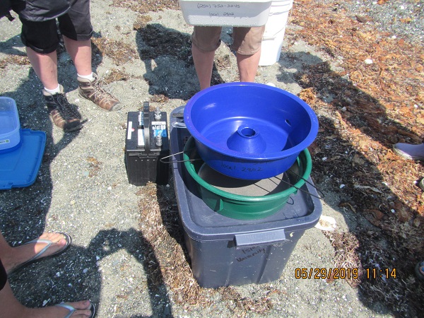
 With the help of volunteers, a total of 83 Cutthroat Trout were captured with a net called a pole seine on three sampling occasions in August, September and October. Each fish was weighed, measured and its adipose fin (tiny fin made of fat at base of tail) was clipped so we can distinguish these Cutthroat Trout from those that enter Shelly Creek via the Englishman River when we operate our
 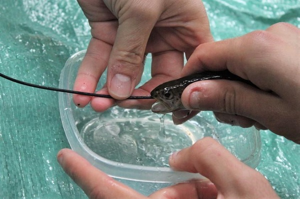 Following these procedures, Braden perfomed a gastric lavage on each fish. I know, it sounds like a menu item for French cuisine. It's actually a scientific term for stomach pumping. It takes quite a bit of skill to extract the stomach contents of a tiny fish without harming it. The stomach contents of each fish were collected, preserved and identified in a lab at VIU. Nice work, Braden! And yes, the fish were released back into the creek, perhaps a little perturbed at having lost their lunch.
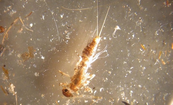 Braden found that half of the items the trout had eaten were the ususal inhabitants of creeks: mayfly nymphs, stonefly nymphs, caddisfly larvae, fly larvae and water striders.
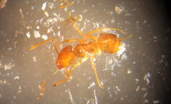 The other half were critters that live on land: pill bugs (or wood bugs) ants, wasps, springtails, beetles and spiders. Wow, half the diet of these trout comes from land! This emphasizes the importance of vegetation along streambanks and tree canopy that hangs over creeks. These insects (and spiders) most likely fell off some foliage overhanging the water. Good to know that the
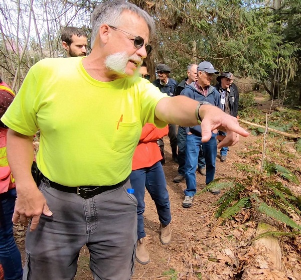
 On the evening of April 3, Storm Cunningham gave an inspiring and informative talk on the strategies used by communities who have revitalized their neighbourhoods and economies by restoring abandoned and deteriorating infrastruture (such as railway bridges and buildings) and remorphed them into facitilies needed for communties to thrive. Storm is from Washington D.C. and the author of "The Restoration Economy", "reWealth", and the soon to be released "RECONOMICS: The Path to Resilient Prosperity". On the last day of the symposium he gave a presentation on how applying the same strategies to land development can lead to restoration of the natural hydrology of creeks and aquifers: by decreasing our destructive footprint while increasing our restorative footprint. “The goal of making the world ‘less worse’ does not go far enough. Rather, we have it within our power to undo previous damage and make the world better."